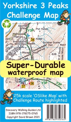
 Yorkshire 3 Peaks Challenge Map & Guide
OSlike Super-Durable Maps designed to help your successful challenge.
Yorkshire 3 Peaks Challenge Maps
Yorkshire 3 Peaks Challenge Map & Guide
OSlike
Super-Durable Maps designed to help your successful challenge.
Yorkshire
3 Peaks Challenge Map at 25k scale with challenge route highlighted. Isbn
9781782750765 £8.99
We licence OS 50k scale mapping which is then doubled in size to produce a 25k
map.
The features, text and logos are now doubled in size making them much easier to
read under challenge conditions.
Y3P 12 Hour Challenge Route is added and specially highlighted so that the route
stands out against the OS background map.
Then we add the additional detail you might need including the popular Challenge
starting points of the Pen Y Ghent Cafe (Horton), Station Inn (Ribblehead) and
the Hill Inn (Chapel-le-Dale).
Then we add the four parts of our Challenge Guide; 1 Horton to Pen-y-ghent, 2
Pen-y-ghent to Whernside, 3 Whernside to Ingleborough, 4 Ingleborough to Horton.
The gps track and 47 waypoints (highlighted on the map) of our Challenge is
available as a free gpx file download, and can be used on all gps phone apps and
gps units.
On the reverse of the map sheet is our Locator Map using OS Opendata showing the location of, and access to, the Yorkshire 3 Peaks Challenge relative to a wide area of England.
The result is a double sided 600mm by 600mm
map design.
We then print the map design on a 100 micron plastic substrate using a special
UV curing inks process on the UK's only press capable of using this latest
technology.
The result is a lightweight map that is both waterproof and tearproof, and fully
recyclable, that will survive anything your Yorkshire 3 Peaks Challenge can
throw at it and afterwards will fold up like new.

![]()
![]()
![]()
For buyers of Yorkshire 3 Peaks Challenge Map we are pleased to offer you a free
Custom Map digital edition for use with Garmin software and gps units, plus use
in Google Earth.
Simply follow the 'Digital Custom Map Edition' information printed on the map
sheet.
To download our gpx file of our 43 waypoints for the Challenge route click
HERE
National 3 Peaks Edale Skyline
Coast 2 Coast Isle of Wight
 Challenge Super-Durable Maps are printed on a special 100 micron plastic substrate
using UV cured inks which produces a lightweight map that feels like
silk while being both water-proof and incredibly tough so that after even the
toughest of adventures your Challenge Super-Durable Map will fold up like
new. All materials used in producing Challenge Super-Durable Maps are 100% recyclable in category 2 HDPE.
Challenge Super-Durable Maps are printed on a special 100 micron plastic substrate
using UV cured inks which produces a lightweight map that feels like
silk while being both water-proof and incredibly tough so that after even the
toughest of adventures your Challenge Super-Durable Map will fold up like
new. All materials used in producing Challenge Super-Durable Maps are 100% recyclable in category 2 HDPE.
Super-Durable Map - 2 Year Guarantee
Click
on the links below to move to another page:
Home Page. Current Titles. Madeira
Mallorca Menorca
Alpujarras Axarquia
Costa Blanca Mountains
Sierra de Aracena
Lanzarote Tenerife
Gran Canaria La Palma
La Gomera Fuerteventura DWG sitemap
Unsure about DWG books and maps? Email us with
your thoughts and ideas.